01 / Proactive methane assessment
Understand what satellite observations reveal about your facility, including detectable methane emissions, their frequency and estimated rates.
Independent satellite methane detection, quantification and monitoring for waste, energy, mining and industrial facilities.

Why it matters now
Satellite methane observations are increasingly public. Organisations need to understand what those observations reveal, whether they are assessing their emissions proactively or responding to an existing alert.
Understand what satellite observations reveal about your facility, including detectable methane emissions, their frequency and estimated rates.
Independent analysis of satellite methane detections to establish what the observations show, assess possible interference and determine whether there is evidence of sustained emissions.
Our standard assessment covers three years of satellite observations and includes:
Repeat monitoring is available. Findings can also support tenders and environmental management proposals.
Proactive assessments · Alert investigations · Repeat monitoring
Request a Methane Assessment
Browse published satellite methane observations, inspect available plume imagery and explore the measurements behind reported hotspots.
Interactive viewer of published satellite observations, including NASA and CAMS/SRON data.
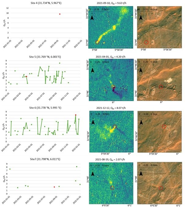
Satellite analysis of Algeria’s Hassi Messaoud oil field (~1,600 km²) from 2021 to 2024. CH4 Sentinel quantified super-emitting plumes in Sentinel-2 SWIR observations; Sentinel-5P TROPOMI inversions provided field-scale context.
N. A. Kinsella and R. McNabb, Proc. SPIE 13671, 2025. DOI: 10.1117/12.3072468
These are independent public scientific reports, prepared by GeoKinsella from openly available satellite data. They are not commissioned client work.
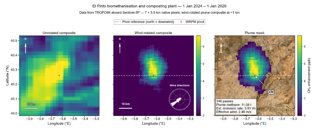
Independent screening of El Pinto Biomethane Plant, near Madrid, using NASA EMIT and DLR EnMAP observations with Sentinel-5P regional context.
Read the report Leer el informe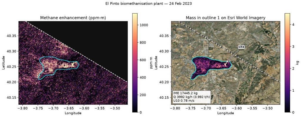
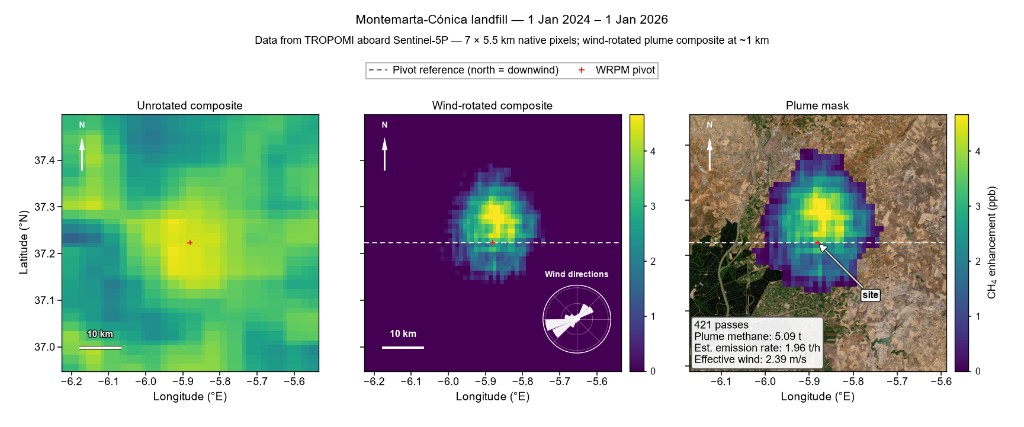
Independent screening of Montemarta-Cónica Landfill, near Seville, using NASA EMIT and DLR EnMAP observations with Sentinel-5P regional context.
Read the report Leer el informe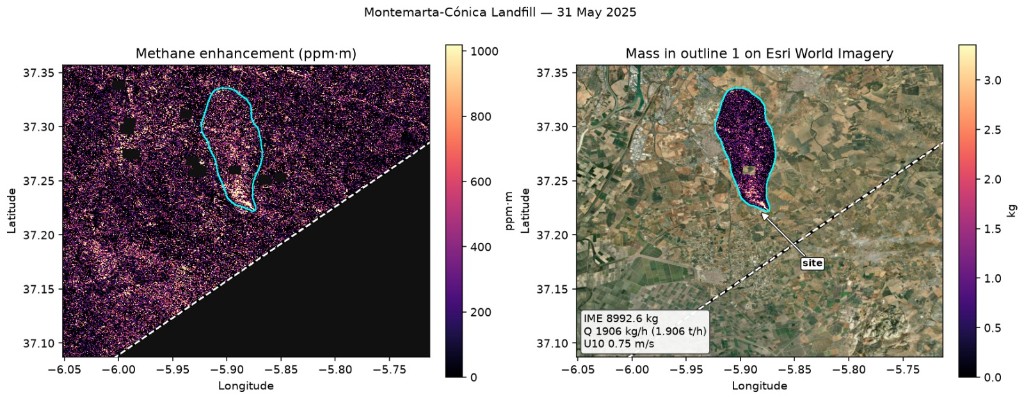

About
I'm a remote-sensing specialist, GIS Project Manager, Earth observation software developer and a Fellow of the Royal Geographical Society. I founded GeoKinsella to provide independent satellite methane detection, quantification and monitoring for waste, energy, mining and industrial facilities.
I design and develop operational Earth observation software, turning satellite data into GIS-ready information for environmental monitoring and decision-making. I've worked with multinational companies and specialist consultancies on commercial geospatial projects. At Telespazio Ibérica, I work on systems for the Spanish electricity sector, covering wildfire detection and prediction, vegetation analysis, machine learning and operational GIS delivery.
Through GeoKinsella, I'm available for independent consultancy, methane analysis, geospatial software and workflow development, and technical presentations and public speaking. I'm based in Córdoba, Spain, and work in English and Spanish.
 MSc GIS, Distinction — Ulster University
 Awarded by the Royal Geographical Society
 Awarded by Ordnance Survey Northern Ireland
 Published author — SPIE conference proceedings
 Developer — CH4 Sentinel
 Featured in Cinco Días / El País
Research presentations


National media recognition
Nicholas Kinsella was featured in Spain's national business press for his work in satellite Earth observation and methane emissions monitoring.
Satellites: a thousand eyes to monitor and act on climate change
Read the article“The real impact is accountability.”
Questions
Not on its own. An alert or catalogue detection shows that a satellite recorded a methane enhancement near a location on a particular date. Neighbouring sources, wind, surface reflectance and retrieval artefacts can all affect what is recorded and where it is attributed, and MARS notifications themselves describe a potential operator, source and magnitude. Our assessment examines each observation to establish what it actually supports.
It depends on the instrument and the conditions. High-resolution instruments such as NASA EMIT and DLR EnMAP can resolve plumes from individual facilities, but only observe a site on some overpasses. Sentinel-5P TROPOMI observes daily at a resolution of several kilometres, which suits regional context rather than attribution to a single facility. Every estimate we report states its uncertainty and the limits of what could be observed.
Often, where enough usable observations exist. We compare all clear overpasses for the period of interest, distinguish repeated detections at the same location from a single event, and note where operating conditions on a given date may explain what was seen. How firm the conclusion can be depends on how often the site was observed.
That is a useful result, but it is not proof of zero emissions. Each instrument has a detection limit and observes the site only at certain times. We report what was observable, what was not detected and the level below which emissions could not have been seen.
Normally not. Satellite assessments can generally be carried out remotely.
Yes. Commissioned assessments and reports are confidential. We do not publish or disclose them, or identify your facility, without your permission, except where the law requires it. The reports published on this website are independent scientific studies based on openly available data, not commissioned client work.
Contact
Whether you want to understand your site’s emissions before anyone asks, or need an independent view of an existing alert, start here.
Your answers help us understand the facility, your assessment objectives and the project scope, so we can follow up with a suitable proposal.
Confidential by default. Commissioned assessments and reports are not published or disclosed, and your facility is not publicly identified, without your permission, except where the law requires it.
For other questions, email us directly: